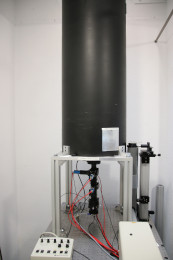
Lidar OPGC
The LIDAR (Light Detection and Ranging) is an optical radar that allows vertical probing of the atmosphere and provides, by active remote sensing, high spatio-temporel resolution profiles of atmospheric constituents such as water vapour, aerosols and upper tropospheric clouds (cirrus). For this, it works by detecting and measuring the laser light backscattering to the reception system composed of mirrors, optics and electronic systems to convert the photons into an electrical signal.
The data produced allow phenomena linked to the presence of aerosols above Clermont-Ferrand to to be observed in real time, in particular:
- Fine particle pollution episodes
- Volcanic ash in the troposphere and the lower stratosphere after a major eruption (Ex: Eyjafjalljökull in 2010)
- The passage of desertic dust, and of particles linked to biomass burning large scale episodes.
- Spatial characterization of cirrus type clouds.
In all cases, the lidar will provide information on the altitude and thickness of the phenomenon.
How to cite :
Baray, J.-L., & Freville, P. (2023). Lidar. OPGC, LaMP. https://doi.org/10.25519/HYHX-NE30
Simple
- Date (Creation)
- 2008-01-01
- Citation identifier
- service / b3097416-eac9-473f-91b5-7408ae6d0cff
- Maintenance and update frequency
- Continual
-
GEMET - INSPIRE themes, version 1.0
-
-
Atmospheric conditions
-
Meteorological geographical features
-
-
Keywords
-
-
Aerosol particles
-
Optical Radar
-
Smog
-
Volcanic ash
-
Desertic dust characterization
-
High clouds characterization
-
-
Resource type
-
-
Service
-
- Use limitation
-
Funding:
- INSU COPDD
- CNES COPDD
- CAES Photons ( https://www.actris.fr/thematiques/caes-photons/ )
- Actris-FR
- Access constraints
- Intellectual property rights
- Use constraints
- Intellectual property rights
- Language
- English
- Topic category
-
- Climatology, meteorology, atmosphere
- Environment
))
- Begin date
- 2008-01-01T00:00:00
- End date
- 2024-12-31T00:00:00
Distributor
- OnLine resource
- LIDAR DOI (OPGC) ( DOI )
- OnLine resource
- LIDAR LaMP Web Site ( WWW:LINK-1.0-http--link )
- OnLine resource
- LIDAR OPGC Quicklooks ( WWW:LINK-1.0-http--link )
- OnLine resource
- LIDAR ICARE Quicklooks ( WWW:LINK-1.0-http--link )
- Hierarchy level
- Service
- Statement
-
data.gouv.fr
Overviews
Spatial extent
Provided by
