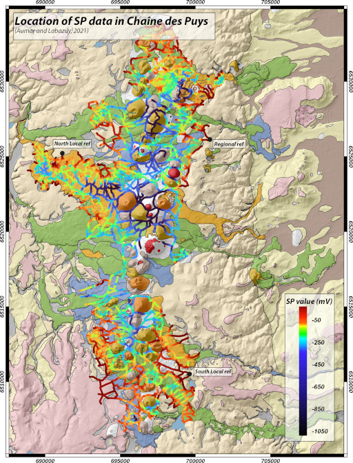
Self Potential data base on the Chaîne des Puys - Dataset
This dataset was created from self potential data acquired over a period of time between 1989 and 2022. The data acquired on the Volvic watershed were first used in a DIREN report (Labazuy, 2000) and in the thesis of Joux (2002). This dataset has been largely completed in the framework of the CAPRICE project (Aumar, 2022) on the Come and Veyre watersheds.
How to cite:
Aumar, C., & Labazuy, P. (2021). Self Potential data base on the Chaîne des Puys [Data set]. OPGC, LMV. https://doi.org/10.25519/ZGHC-N54 3
Simple
- Date (Revision)
- 2022-04-15
- Date (Creation)
- 2022-04-15
- Date (Publication)
- 2022-04-15
- Citation identifier
- dataset / 864924be-6925-4643-9337-96fc04c1a3b2
- Status
- Completed
- Maintenance and update frequency
- Irregular
-
GEMET - INSPIRE themes, version 1.0
-
-
Geology
-
-
Keywords
-
-
Self-Potential
-
hydrogeophysics
-
Chaîne des Puys
-
Volcanics aquifers
-
CAPRICE project
-
-
Type de ressource
-
-
Dataset
-
- Access constraints
- Other restrictions
- Other constraints
- No limitations to public access (INSPIRE)
- Use limitation
-
Funding references:
FEDER Auvergne, AELB (Agence de l'Eau Loire Bretagne)
- Use constraints
- Other restrictions
- Other constraints
-
Creative Commons BY Attribution 4.0 https://creativecommons.org/licenses/by/4.0/
data.gouv.fr
- Language
- English
- Character set
- UTF8
- Topic category
-
- Geoscientific information
))
- Reference system identifier
- https://spatialreference.org/ref/epsg/4326/
- Distribution format
-
-
CSV
(
1.0
)
-
ESRI_shape
(
1.0
)
-
XLSX
(
1.0
)
-
CSV
(
1.0
)
Distributor
- Name
-
XML
- Version
-
1.0
- OnLine resource
- Self Potential dataset of the Chaîne des Puys - DOI (OPGC) ( DOI )
- OnLine resource
- TIFF for 'Self potential map of the Chaîne des Puys' ( WWW:DOWNLOAD-1.0-http--download )
- OnLine resource
- Self Potential dataset of the Chaîne des Puys.zip ( WWW:DOWNLOAD-1.0-http--download )
- OnLine resource
- Self-potential dataset for mapping groundwater flow patterns in the Chaîne des Puys (Auvergne, France) - Data Article ( DOI )
- OnLine resource
- Prevolcanic topography and hydrogeological watershed of the Chaîne des Puys DOI (OPGC) ( DOI )
- Hierarchy level
- Dataset
Conformance result
- Date (Publication)
- 2010-12-08
- Explanation
-
See the referenced specification
- Pass
- Yes
Conformance result
- Date (Publication)
- 2008-12-03
- Explanation
-
See the referenced specification
- Pass
- Yes
- Statement
-
DIREN report (Labazuy, 2000)
Overviews
Spatial extent
Provided by
