 OPGC Catalog
Type of resources
Available actions
Topics
Keywords
Contact for the resource
Provided by
Years
Formats
Update frequencies
status
-
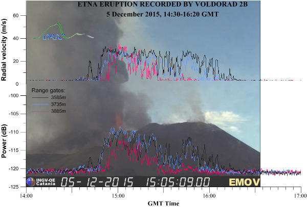
VOLDORAD, namely Volcano Doppler Radar, is a service of the french CNRS-INSU National Service for Observation in Volcanology (SNOV) hosted by the Observatoire de Physique du Globe de Clermont-Ferrand (OPGC), France. It includes a set of transportable radars designed at OPGC, aimed at monitoring and studying explosive volcanic eruptions (volcanic explosion, lava jet, lava fountain, eruption column, tephra plumes) by pointing directly near the source. The core activity of the VOLDORAD service is to provide the scientific community with observational and processed radar data through data bases from continuous monitoring (Etna, Popocatépetl volcanoes) or punctual measurement campaigns (Etna, Stromboli, Yasur, Arenal, Popocatépetl). At Etna, the OPGC radar VOLDORAD 2B is fully integrated into the INGV Osservatorio Etneo monitoring network and operated in collaboration with the INGV sezione di Catania. The radar has been recording raw data (level 0) at 4 Hz from several probed volumes right above the summit craters since 2009 from the Montagnola station on Etna’s south flank. The VOLDORAD 2B open data base comprises the radar products (level 1 data) computed from the raw data by the VOLDORAD service hosted at OPGC. The radar products includes Doppler spectra, velocigrams and time series of backscattered power, radial velocities and other combined radar indices. The main interests of such Doppler radars is their capacity to be transported in the field, to probe inside volcanic plumes or jets, and to track in real-time the ejecta velocity and reflectivity near the source, thus providing some quantification of the temporal evolution of eruption intensity, through all weather. Direct radar retrievals are particle along-beam velocity components and backscattered power, in successive probed volumes inside the beam. Physical parameters that can be derived from the radar retrievals (Donnadieu, 2012; Donnadieu et al., 2005, 2016) are particle ejection velocities, mass flux of tephra, gas initial velocity and gas mass flux estimates, eruption duration, total solid mass, 3-D transport speed of tephra, amount of ballistics and wind-advected tephra, all weather early warning of tephra emission. How to cite : DONNADIEU, F., FREVILLE, P., RIVET, S., HERVIER, C., & CACAULT, P. (2015). Volcano Doppler Radar Data Base of Etna (VOLDORAD 2B). Université Clermont Auvergne – CNRS. https://doi.org/10.18145/VOLDORAD.ETNA.2009
-
Rewriting in C language, optimization and integrability in various platforms as Virtual Reality from VolcFlow Matlab numerical model one-fluid version. How to cite : Delage, E., & Kelfoun, K. (2020). VolcFlow-C. Observatoire de Physique du Globe de Clermont-Ferrand (OPGC). https://doi.org/10.25519/VOLCFLOW-C
-

StereoVolc - Merapi Data of the StereoVolc stations installed at Merapi volcano, Indonesia..4 stations in stereoscopic configuration have been installed from 2013 on the flanks and the summit of Merapi. The stations have been developped at OPGC by the SDT. Thierry Latchimy was in charge of the electronic & computer/network development, Martial Bontemps of the technical & field robustness aspect and Karim Kelfoun of the scientific issues. The developpment of the system and the field installation was found by the ANR-project Domerapi, the LabEx ClerVolc, IRD and OPGC. Données des stations StereoVolc installées sur le volcan Merapi, en Indonésie. Depuis 2013, 4 stations ont été installées en configuration stéréoscopique sur les flancs du Merapi et à son sommet. Les stations ont été développées à l'OPGC par le SDT (Service de Développement Technologique). Thierry Latchimy a été responsable du développement électronique & informatique/transmission, Martial Bontemps des aspects techniques & robustesse terrain et Karim Kelfoun des problématiques scientifiques. Le développement du système et l'installation ont été financés par le projet ANR Domerapi, le LabEx ClerVolc, l'IRD et l'OPGC. The installation, conception and maintenance were possible thanks to / la conception, l'installation et la maintenance ont été rendues possibles grâce à : François Beauducel, Ali Fahmi, Nabil Dahamna, Mochammad Husni Rizal, Jatmika Teja Sukmana, Rizal, Antoine Laurin, and , Agus Budi, Ilham Nurdin and the staff of BPPTKG. How to cite: Kelfoun, K. (2023). StereoVolc [Data set]. OPGC, LMV. https://doi.org/10.25519/STEREOVOLC
-
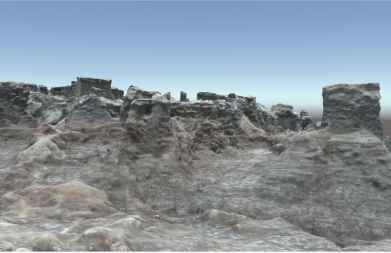
This 3D model was performed by Agisoft Metashape Professional Edition software (Educational License). Digital images were taken by Olivier Grunwald, french photographer. This work is part of Erasmus+ Key Action 2 2017-1-UK01-KA203- 036719 '3DTeLC – Bringing the 3D-world into the classroom: a new approach to Teaching, Learning and Communicating the science of geohazards in terrestrial and marine environments'. The generated OBJ tiled model was tested on GeaVR and VRVolc Virtual Reality softwares (See links below). How to cite: Delage, E., Grunwald, O., & van Wyk de Vries, B. (2023). Topographic 3D model : Dallol canyons [Data set]. OPGC. https://doi.org/10.25519/7A8B-EX89
-

Atmospheric aerosols have been identified as essential climate variables by international programs, notably GCOS (Global Climate Observing System) and GAW (Global Atmosphere Watch). The objective of CLAP is to contribute to the monitoring of this variable based on regular measurements. The observations of this service must be used to evaluate in a context of climate change - the long-term evolution of certain important sources of aerosol, - the long-term evolution of the aerosol load for different size classes and for different chemical species, - possible retroactions of the aerosol towards the climate through its optical and cloud condensation core properties. This service completes the national SNO landscape for monitoring atmospheric composition and is integrated into the proposed structure of IR ACTRIS-Fr. CLAP is part of the French contribution to the European Research Infrastructure ACTRIS-ERI, submitted for integration into the ESFRI roadmap. Parameters measured: Aerosols: particle size, number per particle size class, chemical composition on filter (EC-OC Soluble inorganics, optical properties, hygroscopic properties. Location of the sites: The SNO CLAP includes 5 sites at altitudes varying from 1465 m to 5240 m at above sea level, and two lowland sites, located on 4 different continents The high altitude sites can be either in atmospheric boundary layer (CLA) or in free troposphere (TL) depending on atmospheric conditions and climate. Puy de Dôme, Maïdo, Pic du Midi, Nepal (Khumbu valley at 5079 m), Bolivian Andes Cordillera (at 5240 m), SIRTA, the Perennial Observatory of the Environment (OPE) (high point at almost 395 m between the center of the Paris basin and the Vosges) Database: http://ebas.nilu.no Network: ACTRIS, GAW
-
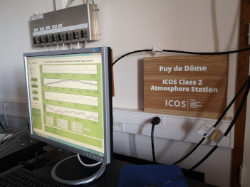
ICOS is a European infrastructure with ERIC status, registered on ESFRI roadmap. At French level, ICOS-France is also a TGIR (Very Large Research Infrastructure), labeled by MENESR. The ICOS-atmosphere part (also called RAMCES) also has labeling as SNO. The scientific objective of ICOS is the description of biogeochemical cycles of the main additional greenhouse gases (CO2, CH4, N2O, SF6) and quantification of carbon balances on a regional scale. Concerning atmospheric compartment ICOS aims at long-term monitoring of atmospheric concentrations of additional greenhouse gases. These measurements will make it possible to quantify +9surface emissions on a national and regional scale, by inverse modeling of atmospheric transport. Location of sites: SNO-ICOS-Atmosphere comprises nine stations in mainland France, including five tall towers (Trainou, Saclay, OPE/ANDRA, OHP, Roch-Tredudon), two assembly stations (Puy-de-Dôme , Pic du Midi), and two coastal resorts (Ersa, Biscarrosse). This network is completed by 3 stations in overseas territories (Ile Amsterdam, OPAR, Guyaflux), two European stations (Mace Head, Finokalia) and two tropical stations (Lamto, Chacaltaya). Parameters measured: CO2, CH4, N2O, SF6, H2, CO, Radon-222, 13C and 18O isotopes of CO2. Database: https://ramces.lsce.ipsl.fr/ https://icos-atc-demo.lsce.ipsl.fr/ https://ghg-europe.lsce.ipsl.fr/ http://www.esrl.noaa.gov/gmd/ccgg/globalview/co2/co2_intro.html Networking: ICOS, GAW/WMO
-
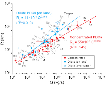
This dataset presents the main characteristics of well-documented pyroclastic density currents and their related eruptions. How to cite: Roche, O., (2024). Pyroclastic density currents (Version 1) [Data set]. OPGC, LMV. https://doi.org/10.25519/Z1KW-N075
-

Julia Eychenne 1,2, Lucia Gurioli 1, David Damby 3, Corinne Belville 2, Federica Schiavi 1, Geoffroy Marceau 2,4, Claire Szczepaniak 5, Christelle Blavignac 5, Mickael Laumonier 1, Emmanuel Gardés 1, Jean-Luc Le Pennec 6,7, Jean-Marie Nedelec 8, Loïc Blanchon 2, Vincent Sapin 2,4 1 Université Clermont Auvergne, CNRS, IRD, OPGC, Laboratoire Magmas et Volcans, F-63000 Clermont-Ferrand, France 2 Université Clermont Auvergne, CNRS, INSERM, Institut de Génétique Reproduction et Développement, F-63000 Clermont-Ferrand, France 3 U.S. Geological Survey, California Volcano Observatory, Moffett Field, CA, USA 4 Biochemistry and Molecular Genetic Department, University Hospital, F-63000 Clermont-Ferrand, France 5 Université Clermont Auvergne, UCA PARTNER, Centre Imagerie Cellulaire Santé, F-63000 Clermont-Ferrand, France 6 Geo-Ocean, CNRS, Ifremer, UMR6538, F-29280 Plouzané, France 7 IRD Office for Indonesia & Timor Leste, Jalan Kemang Raya n°4, Jakarta 12730, Indonesia 8 Université Clermont Auvergne, Clermont Auvergne INP, CNRS, ICCFn, F-63000 Clermont-Ferrand, France How to cite: Eychenne, Julia. (2022). Dataset for "Spatial distribution and physicochemical properties of respirable volcanic ash from the 16-17 August 2006 Tungurahua eruption (Ecuador), and alveolar epithelium response in-vitro" published in GeoHealth [Data set]. Zenodo. https://doi.org/10.5281/zenodo.7094614
-
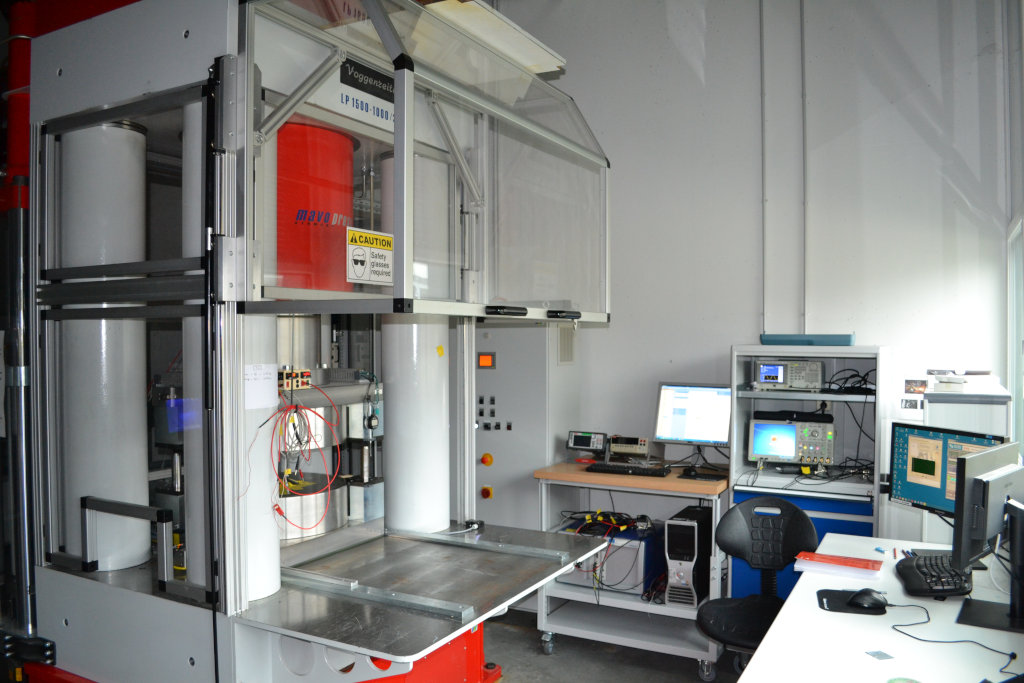
The multi-anvil press at the Labotaoire Magmas and Volcanoes is capable of generating pressures between 3 and 26 GPa at temperatures of up to 2300°C. Accurate control over the pressure and tempera conditions of experiments, low thermal gradients, the virtual absence of pressure gradients at high temperatures, and large sample sizes (compared with available characterization tools such as optical microscopes, electron or ion microprobes, scanning or transmission electron microscopes, laser ablation systems, Raman or infrared micro spectrometers), make the multi-anvil press an ideal instrument for synthesizing or studying of solids, liquids or fluids phases at high pressures and temperatures. How to cite: Manthilake, G. (2023). Multi-anvil press. OPGC, LMV. https://doi.org/10.25519/MULTI-ANVIL-PRESS
-
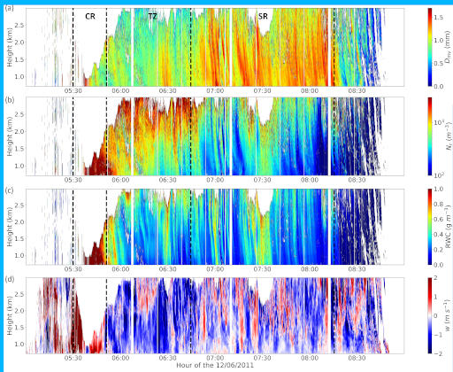
This dataset contains the mean raindrop volume diameter Dmv, the total raindrop concentration Nr, the rain water content RWC and the vertical wind speed w obtained by a retrieval technique combining the observations from two collocated and zenith pointing Ka and W-band radars at two sites in Finland (07/06/2014) and Oklahoma (12/06/2011). How to cite: Niquet, L., Tridon, F., & Planche, C. (2024). Evaluation of the representation of raindrops self-collection and breakup processes in 2-moment bulk models using multifrequency radar retrievals [Data set]. OPGC, LaMP. https://doi.org/10.25519/1GB0-1C84